
Built (#21/2026)
Short, interesting, engineering & infrastructure posts. One email every Sunday

Gariep Dam
South Africa's largest dam, Gariep Dam on the Orange River. Currently at 113% full. Sluices opened full throttle.
What a sight.
The dam holds 5.34 billion m3 of water.
The structure itself is a gravity-arch hybrid, a design chosen specifically because the gorge was too wide for a pure arch dam.
Where the valley narrowed, a central arch carries the load.
Where it widened at the flanks, gravity sections take over, bearing the water pressure through mass alone.
The wall is 88 metres high and 914 metres long, containing around 1.73 million m3 of concrete.
Four turbines, each rated at 90 MW, give the power station a combined output of 360 MW.
That is enough to supply roughly 70,000 households.
It was ompleted in 1972, by a French-South African construction consortium after nearly a decade of work.
-
Some of the dam's most remarkable engineering feat is actually what happens underground.
From the southern bank of the reservoir, an 82.8-kilometre tunnel bores through the Suurberg Mountains, carrying water from the Orange River catchment all the way to the Great Fish River valley in the Eastern Cape.
The Orange-Fish Tunnel, completed in 1975.
It is the longest continuous enclosed aqueduct in the southern hemisphere.
Its finished internal diameter is 5.35 metres, and it runs at a gradient of 1 in 2,000, relying entirely on gravity to move water across the watershed.
The curvature of the Earth was significant enough over that distance that engineers had to account for it in their survey calculations.
The alignment error across the full length was less than 4 millimetres.
The tunnel now carries an average of 22 m3/s of water, supplying towns and irrigation schemes across the semi-arid Eastern Cape.
The dam was originally named after Hendrik Verwoerd, the apartheid-era prime minister who commissioned the project. This was changed to Gariep in 1996, using the Khoekhoe word for river, which was also the original name of the Orange River itself.
Much prettier name.
SANAE IV
This is SANAE IV, South Africa's base in the Antarctic. The previous three bases were all crushed by snow. It opened in Jan '97 and was the first to be built somewhere snow could not bury it.
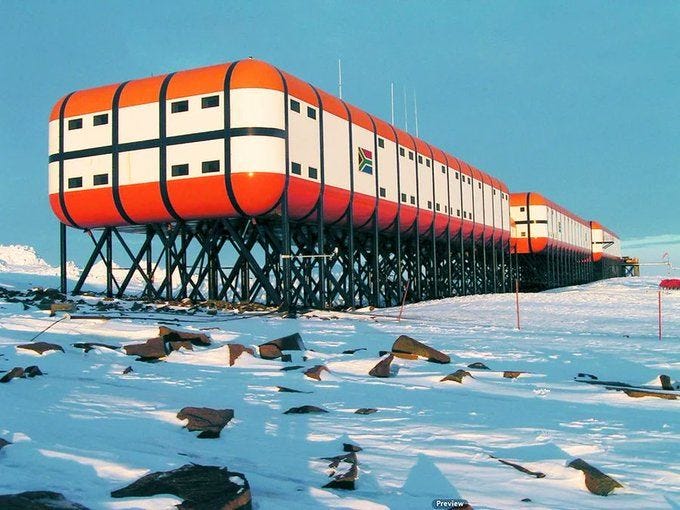
Its predecessors sat on the Fimbul ice shelf, near the coast.
Each one was slowly entombed as years of accumulating snow piled on top of it, eventually deforming the structure under its own weight.
SANAE III was abandoned in 1994 for exactly this reason.
The solution was to abandon the ice entirely.
SANAE IV was placed atop Vesleskarvet, a flat-topped rocky outcrop, protruding through the ice sheet roughly 170 kilometres inland from the coast in Queen Maud Land.
The base sits at about 850 m above sea level, around 4,280 km from Cape Town (from where it is serviced)
The structure is three linked double-storey modules, each 44 m long and 14 m wide, joined end to end and aligned north to south.
The whole assembly is raised about 4 m above the rock on steel stilts anchored directly into the nunatak.
That gap is the entire point.
Prevailing winds blow underneath the base at full speed, scouring loose snow away before it can settle.
The base itself is positioned near the downwind cliff edge of the nunatak, so any snow that drifts past is carried straight over and dumped onto the ice sheet below.
The British Halley V had already used jacking stilts on the ice shelf a few years earlier, so the elevated concept was not entirely new.
What SANAE IV did differently was combine the stilts with solid rock and a downwind cliff, so the wind permanently does the scouring without any need to keep raising the building.
That refinement became a template.
Germany's Neumayer Station III, the British Halley VI, India's Bharati, South Korea's Jang Bogo, and Brazil's rebuilt Comandante Ferraz all followed in the years afterwards, each on stilts and each shaped to let wind carry snow past rather than pile it up.
Wind speeds at the SANAE IV site routinely sit around 11 m/s on average, with recorded gusts above 40 m/s.
The design specification covered sustained winds of up to 250 km/hr and temperatures down to minus 55 degrees Celsius.
Most of the structure was prefab in South Africa and shipped in containers, because the construction window each year was only the four summer months.
The frame is steel, clad in rigid prefabricated panels of foam and fibreglass for insulation.
Power comes from three 250kW diesel generators, with their exhaust heat recovered to warm the living quarters.
Drinking water is produced by a snow smelter sited away from the base, which has to be manually topped up with fresh snow.
Nearly thirty years after opening, the base is still operational.
A clever piece of South African mechanical and structural engineering that set the pattern for a generation of polar stations to come
Cofferdams
built inside a body of water, allowing the area within to be pumped dry for construction.
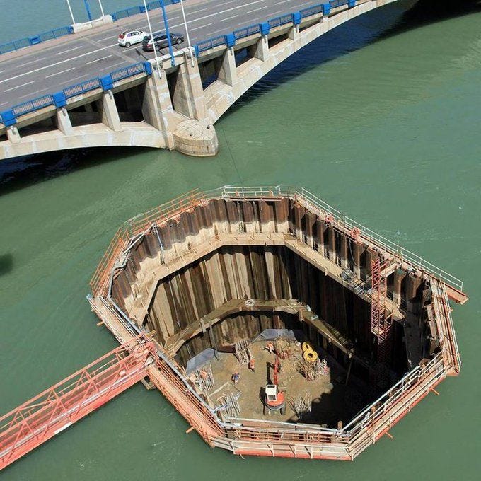
It looks dangerous.
And it is — if you don’t use competent civil engineers.
A great deal of engineering and material science goes into safely designing and installing these systems, because the walls are holding back a vast, unforgiving load that never pauses while people work below the waterline.
Hydrostatic pressure rises linearly with depth
(the same pressure you feel when diving deep in a pool, only far greater on the walls the deeper you go).
Soil stability, tidal variation, and seepage paths beneath the wall all have to be modelled before a single sheet pile is driven.
Geotechnical analysis determines bearing capacity, the risk of piping through the foundation, and exactly how deep the piles must reach to maintain a continuous seal.
Then comes the question of support.
Shallow installations often rely on internal bracing across the enclosed space. But in deeper water, this becomes impractical, so the design shifts to cellular sheet-pile cofferdams filled with granular material.
These structures stabilise themselves by sheer mass.
No internal bracing.
No obstruction inside the work area.
For trickier sites, double-walled configurations or inflatable seals provide the needed adaptability.
Once the wall is in place, continuous monitoring is essential.
Leaks, settlement, lateral movement, and pore pressures in the surrounding soil are all tracked. Any deviation from the design envelope signals trouble ahead.
Gone are the days of surveyors taking manual readings at fixed intervals. Modern cofferdams stream real-time data from vibrating wire piezometers, MEMS inclinometers, and automated dataloggers — systems that can trigger alarms the instant a threshold is crossed.
On a deep cofferdam, those extra minutes of warning can be the difference between a controlled fix and catastrophic failure.
Cellular cofferdams remain one of the few viable options beyond 20 metres of water depth, which is why you’ll see them used for lock walls, offshore platform foundations, and the construction or repair of permanent dams.
What looks from above like a steel ring full of mud and pumps is actually a carefully balanced structure holding back enormous forces.
Some seriously clever civil, mechanical and geotechnical engineering!
Submerged Arc Welding
This is Submerged Arc Welding, the heavy industry workhorse that buries the arc under a blanket of granular flux to shield molten steel from atmospheric contamination.
The arc is invisible during welding.
That flux blanket does two jobs at once.
It shields the weld pool from oxygen and nitrogen, and it concentrates the heat downward so almost none of it radiates away, pushing thermal efficiency to around 60%, which is exceptional for an arc process.
The productivity gain is real.
Single wire SAW lays down weld metal at roughly 45 kilograms per hour, compared to about 5 kilograms per hour for traditional stick welding, a ninefold jump that allows thick steel joints to close in a single pass.
We recently used SAW on a 35-tonne agitator bridge bound for a mining client in Madagascar (photo in the comments).
The electrode wire feeds continuously from a spool, so there is no need to stop every few minutes to swap a stick.
The welder monitors rather than holds the arc, which dramatically cuts fatigue on long seams and lets one operator run a job that would have needed a team of stick welders working in shifts.
The flux performs a second clever trick.
Unused granules are vacuumed back through a recovery nozzle (the one closest to the camera in the video) and returned to the hopper, with between 50 and 90% of the flux reused over the course of a job.
The fused portion forms a glass like slag over the cooled weld, which lifts off in clean sheets once the bead drops below red heat.
Because the arc is buried, there is almost no spatter, no ultraviolet flash, and very little fume.
The trade off is geometry.
SAW only works flat or horizontal, because gravity holds the flux blanket in place, which rules out vertical seams or anything overhead.
The process was patented by Robinoff in 1930, refined for longitudinal pipe seams at the National Tube Company in Pennsylvania, and scaled massively during the Second World War for shipyard hull plate and ordnance fabrication.
Nearly a century on, SAW still does the heavy lifting in pressure vessel shops, pipe mills, structural engineering fabricators, and our own workshop floor.
Google Maps Traffic Jams
How does Google Maps know there is a traffic jam? Because your phone is basically a tiny traffic sensor.

Google Maps doesn’t “see” traffic; it measures behaviour.
Thousands of phones on the same road continuously send anonymised GPS location and speed data back to Google's servers.
Each ping carries coordinates, velocity, and a timestamp, and arrives at rates measured in the billions per day.
The system groups these signals by road segment.
Then compares current speeds against historical patterns for that exact time and day of the week.
When vehicles slow from 60 km/h to 10 km/h on a stretch that normally flows freely, the segment is flagged as congested and turned red in near real time.
The latency from your phone slowing down to the map updating is reportedly under two minutes.
-
Waze, acquired by Google in 2013, feeds a different data stream into the same engine.
It's still a maintained separate app.
Waze users actively report accidents, road closures, hazards, and police presence, and that information flows directly into Google Maps.
In return, Google's vastly larger pool of probe data improves Waze's routing and traffic predictions.
The system also pulls in feeds from local transport authorities, traffic cameras, and pattern libraries built from years of prior trips on the same road.
-
Predicting traffic ten or twenty minutes ahead is a harder problem.
Live data only tells you what is happening right now.
To solve this, Google Maps engineers partnered with DeepMind and applied a machine learning architecture called Graph Neural Networks.
Roads are modelled as edges, intersections as nodes, and the network learns how congestion at one point ripples outward across the surrounding grid.
DeepMind reports the approach has lifted estimated time of arrival accuracy by up to 50% in cities such as Berlin, Jakarta, Tokyo, and Sydney.
Maps stitches the network into roughly kilometre-long stretches called supersegments, which the model treats as the basic unit of prediction.
All of it runs on data your phone contributes silently, whether or not the app is open on your screen.
Google knows everything about you.
Slauerhoffbrug
The beautiful Slauerhoffbrug, the iconic flying drawbridge of Leewarden, Netherlands. A gorgeous example of bridge and structural infrastructure swings an entire section of road into the air in 3 min, allowing boats to pass underneath without the need for conventional hinged mechanisms.
It is a tail bridge, a variant of the bascule family, in which a single pylon and two arms lift the deck clear of the road, rather than tilting it about a hinge along one edge.
The roadway is not hinged at all.
The entire 15 by 15 metre section is hoisted clear of the canal, leaving a clean opening above the Harlingervaart for boats to pass below.
Two hydraulic cylinders, each 360 mm in diameter and 4.1 metres long, drive the lift through a pair of arms set at a diagonal to the road.
At full extension, the deck sits roughly 45 metres above the water, and the bridge runs around ten times a day.
The L-shape of the structure is deliberate, bending the bearing bars toward the deck and dispensing with the principal beams and cross girders you would normally expect beneath.
That gives a lower construction depth, which buys more lift height for the same pylon.
When raised, the deck is visible from across the city, an outcome of the structural choice rather than any added ornament.
The yellow-and-blue paint scheme is taken from the Leeuwarden flag.
Locals also call it the Kikkerbrug, or Frog Bridge, for the squat shape it takes when lowered.
Completed in 2000 and designed by the Dutch engineering firm Van Driel Mechatronica, it remains one of the more unusual movable bridges in service anywhere.
Most opening bridges use one of three approaches: a hinged leaf that tilts upwards, a vertical lift between towers, or a swing span that pivots horizontally.
The tail bridge sits outside all three.
It solves the same problem with a different geometry, and does it with one moving pylon.